

Data centers have a certain look in the popular imagination: grey, sleek, boxy, expansive. We have all seen one by now: the aerial photograph – probably by a camera tacked to a drone – with an oblique view of a clean, virtually windowless building that we have learned to identify as a data center. It’s a humanly impossible view becoming more mundane by the minute. What would it take to disrupt this data center icon to make it more authentic, real, complicated? And why would a new visual paradigm matter?
I’ve been wanting to explore these questions all year, and I finally have the perfect opportunity. Stephen Voss – an award-winning photographer who shoots for clients like Time, National Public Radio, WIRED, and Outside – has a new portfolio of work with data centers as subject. Below is my interview with Stephen.
JF. Your series Dark Fiber represents years of effort. What do you know now about photographing data centers that you did not know when you started?
SV. Thanks for your interest in the work.
First off, it’s hard to make an interesting photo of a data center! It takes a combination of research, hours of driving around (Google Street View is almost always outdated, as are satellite photos), and a bit of luck to find scenes that might result in good photos. I’ve also learned how important it is to return to places time and time again. The landscape is changing so rapidly here. Sometimes, I’ll try to revisit a place only to find it fenced off and inaccessible. What I feel more than anything now is an urgency to do this work, to create a record of this time.
JF. Your photo of the youth striding on the green expanse of the baseball field at night is a study in contrast and scale: a data center construction site looms in the darkness behind him, overpowering his small figure. You captured this view at Sully Highlands Field in Herndon, Virginia. What would you like viewers to see or feel through this image?
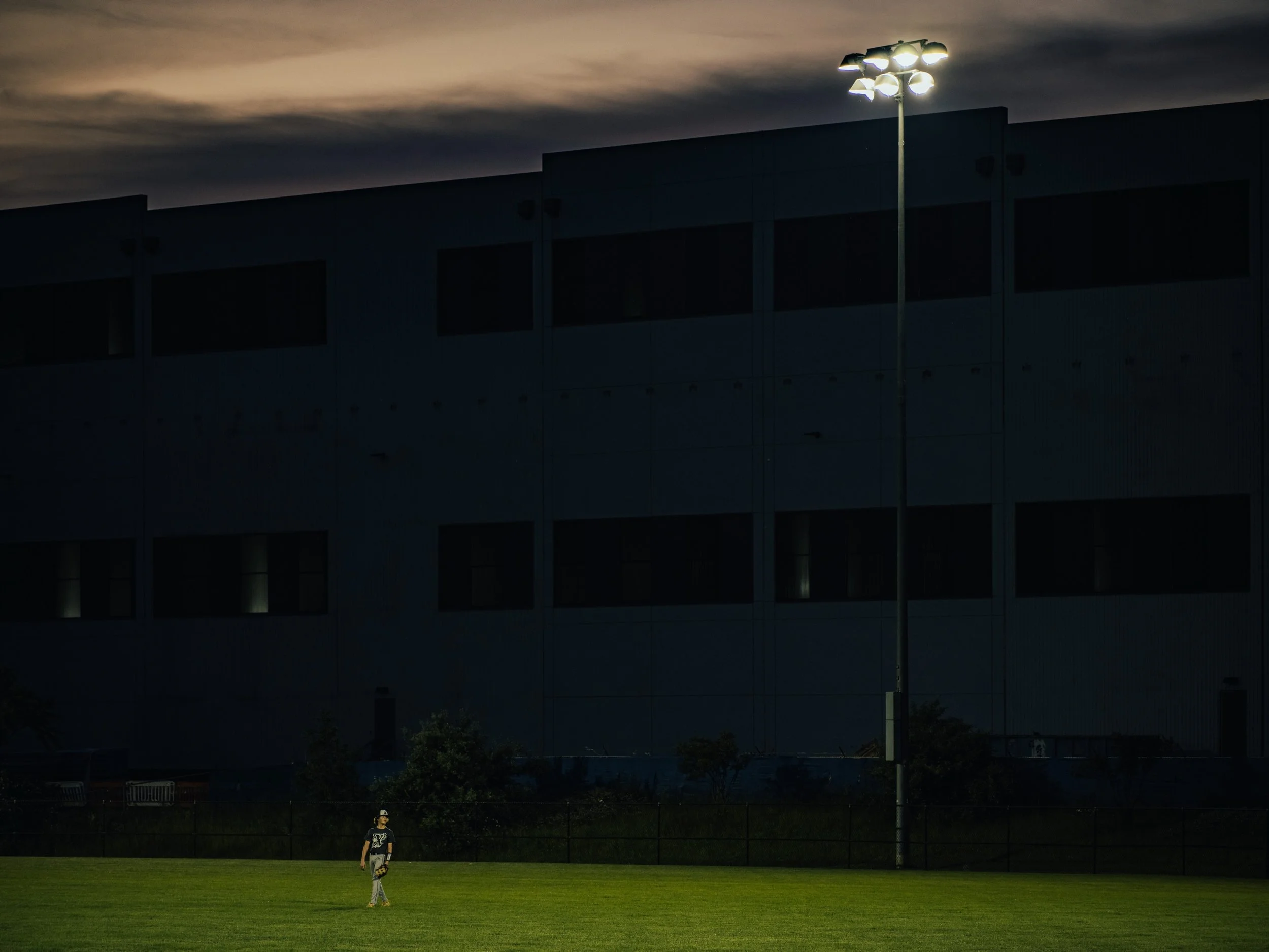
A baseball practice at Sully Highlands Field, near a data center under construction, in Herndon, Virginia. Photo: Stephen Voss
SV. What drew me into this project was understanding how these communities bear the weight of our digital lives. Much of what we take for granted when we stream music, share photos or prompt an AI is dependent on these buildings. In Northern Virginia, the places that define the community - where people live, work, play and even bury their dead, have been irrevocably changed by the presence of this build out.
JF. Every Past and Tomorrow is the name of your photo book project, showing how AI infrastructure collides with homes, forests, cemeteries, and history in northern Virginia. When and how did the idea for creating the book come to you?
SV. Three years ago, I was driving back from a photo shoot in Virginia when I noticed a data center for the first time, in all its massive, boxy glory. Here was the physical reality of “the cloud.”
That disconnect stuck with me. While I mostly make my living shooting portraits of politicians for magazines and newspapers, I have a degree in computer science and have had a lasting interest in technology. I wanted to see what our digital lives actually looked like on the ground.
Northern Virginia has the highest concentration of data centers in the world, just a short drive outside of Washington, DC, where I live. I began making regular trips into this landscape of upscale homes, athletic fields, historic cemeteries and enormous, industrial buildings built for machines.
The more I explored, the more I wanted to photograph the relationships between those places. Where does a data center end and someone’s neighborhood begin? What does it look like when the industrial infrastructure that supports our digital lives becomes part of someone’s daily life?
The project became Every Past and Tomorrow. For communities elsewhere in the country facing their own data center boom, Northern Virginia offers a glimpse of what may be coming.
JF. What can the photo book do that a digital screen cannot?
SV. A photo book is a contained experience – all that you need to know is in those pages. Within that constraint, you can sequence images to create a sort of rhythm, to make juxtapositions that heighten the effect of each photo, and give viewers a visual vocabulary through which they can be taken to unexpected and revealing places.
Design choices can complement and enliven the effect of viewing the images. A great photo book encourages repeated viewings and a deeper understanding of its intent is revealed over time.
JF. There’s a poignant photo in the series that shows a family headstone nestled in brush at Tippett’s Hill Cemetery, with a data center not far behind. What does this image do to break the prevailing paradigm in data center photography?
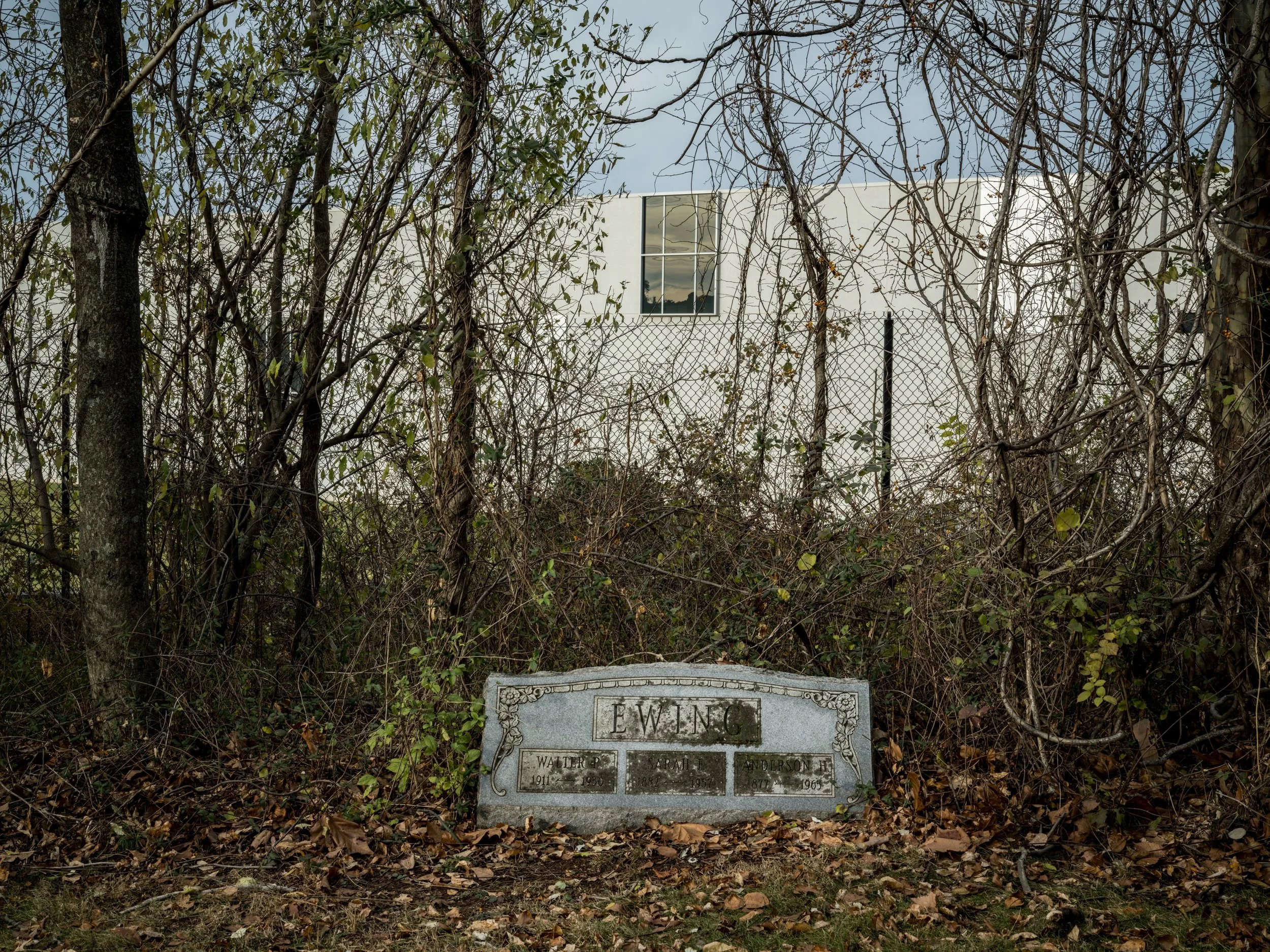
A data center overlooks Tippett’s Hill Cemetery, one of the largest and oldest African-American cemeteries in Loudoun County, Virginia.
SV. Tippett’s Hill Cemetery is an African American cemetery with gravestones dating back to the 1700s, and remains in active use by the Nokes family. When I made that photograph of the headstone, there were data centers on two sides of it. In the past year, construction began on the third.
If you look at most of the imagery of data centers that exists, they tend to show little of what’s around them. These photos are meant to push back on the idealized portrayal we see of these buildings as is commonly shared. That said, I’m not interested in a doom and gloom perspective, but rather an honest look at the state of things in Northern Virginia.
JF. Your work conveys a mix of photography taken from the ground and sky. What did you need to do tactically for your aerial projects over Stargate in Abilene, Texas and Colossus xAI in Memphis, Tennessee? (Available on YouTube here and here)
SV. In both Abilene, Texas, and Memphis, Tennessee, the data centers were in unrestricted airspace. This meant I was able to fly a drone in order to record an aerial view of them. Often, the difficulty in these situations is finding a safe place to take off from where I can track the flight of the drone, so I spent quite a while driving around their perimeters to find an appropriate spot.
JF. In a critique of the technology sector’s photos for corporate public relations, Kelly Gates wrote,
the tech industry does as much as possible to make data centers look like aesthetically pleasing architecture, to present the expanding computational infrastructure as foreordained, and to represent these sites of industrial computing activity as existing in harmony with the communities where they are located. This visual strategy of beautification, inevitability, and communality merges with another strategic message that has become obligatory across these corporate communications: an intense focus on environmental sustainability. Drone photography has been instrumental in this strategic effort.[1]
To what extent do you agree or disagree?
SV. Very well said. And while drone photography has been utilized by those looking to beautify the data center, it can also be highly effective in showing context – how a thin line of trees separates one from a house or to show scale in relation to what’s around it.
I come to this work as an independent photographer with a background in photojournalism. My take is just as subjective as anyone else’s, but I’d like to think it is well-informed and hopefully well-considered. My hope is that this work is an honest portrayal of this community and a push-back against a more sanitized and glossed-over representation of this infrastructure.
JF. How can people get acquainted with your photography?
SV. After three years of photographing the data centers, I’m working on a book of these images and have started a Kickstarter for it here:
I’m working with an amazing designer, and writers contributed original pieces to help frame and push the work in different directions.
My website and Instagram are good places to track what I’m up to and I write an occasional Substack on photo history and other topics that pull me in.
Glyptique Consulting LLC is an advisory partner helping investors in the AI infrastructure value chain translate diffuse signals about regulatory, reputational, and ESG constraints into clear communication and stewardship strategies.
Request a complimentary conversation here.
November 19, 2026
Endnote
[1] Kelly Gates, “Infrastructure Photography and the AI Data Center Building Boom,” Photography and Culture no. 18:3-4 (2025), 263-279, https://doi.org/10.1080/17514517.2025.2473149
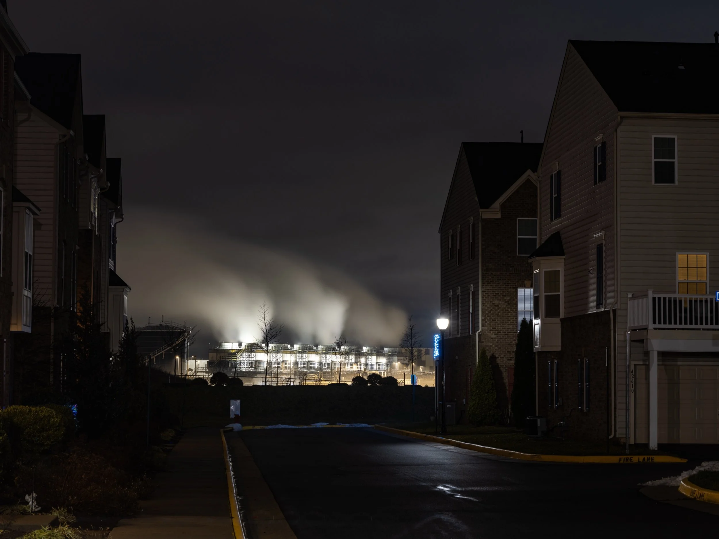
A data center near a housing development, in northern Virginia. Photo: Stephen Voss
